


PR 01

COMAN
User
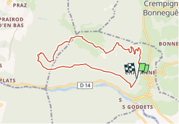

Length
8.4 km

Max alt
931 m

Uphill gradient
524 m
Km-Effort
15.5 km

Min alt
463 m

Downhill gradient
533 m
Boucle
Yes
Creation date :
2021-10-06 13:49:58.475
Updated on :
2022-12-11 19:38:38.24
3h30
Difficulty : Difficult

FREE GPS app for hiking
 SityTrail
IGN / Geographical institutes
SityTrail Plus
The world is yours!
About
Trail Walking of 8.4 km to be discovered at Auvergne-Rhône-Alpes, Upper Savoy, Vallières-sur-Fier. This trail is proposed by COMAN.
Positioning
Country:
France
Region :
Auvergne-Rhône-Alpes
Department/Province :
Upper Savoy
Municipality :
Vallières-sur-Fier
Location:
Val-de-Fier
Start:(Dec)
Start:(UTM)
724351 ; 5090869 (31T) N.
Comments