


Grignan 16,5km

thonyc
User GUIDE
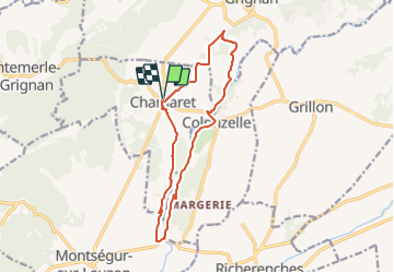

Length
14.2 km

Max alt
212 m

Uphill gradient
204 m
Km-Effort
17 km

Min alt
133 m

Downhill gradient
205 m
Boucle
Yes
Creation date :
2021-10-06 15:35:36.505
Updated on :
2021-10-07 12:15:20.444
4h00
Difficulty : Easy

FREE GPS app for hiking
 SityTrail
IGN / Geographical institutes
SityTrail Plus
The world is yours!
About
Trail Walking of 14.2 km to be discovered at Auvergne-Rhône-Alpes, Drôme, Chamaret. This trail is proposed by thonyc.
Positioning
Country:
France
Region :
Auvergne-Rhône-Alpes
Department/Province :
Drôme
Municipality :
Chamaret
Location:
Unknown
Start:(Dec)
Start:(UTM)
649910 ; 4917743 (31T) N.
Comments