


les Michels de daniel

Coryphene
User
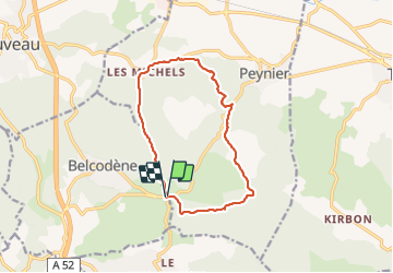

Length
12.9 km

Max alt
449 m

Uphill gradient
268 m
Km-Effort
16.5 km

Min alt
280 m

Downhill gradient
267 m
Boucle
Yes
Creation date :
2021-10-07 07:52:00.38
Updated on :
2021-10-27 15:51:12.297
3h46
Difficulty : Easy

FREE GPS app for hiking
 SityTrail
IGN / Geographical institutes
SityTrail Plus
The world is yours!
About
Trail Walking of 12.9 km to be discovered at Provence-Alpes-Côte d'Azur, Bouches-du-Rhône, Peynier. This trail is proposed by Coryphene.
Positioning
Country:
France
Region :
Provence-Alpes-Côte d'Azur
Department/Province :
Bouches-du-Rhône
Municipality :
Peynier
Location:
Unknown
Start:(Dec)
Start:(UTM)
711307 ; 4810644 (31T) N.
Comments