


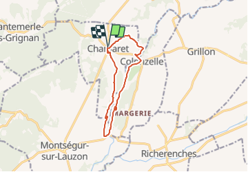
SityTrail - Chamaret Rochecourbière 14km

thonyc
User GUIDE

Length
11.1 km

Max alt
212 m

Uphill gradient
171 m
Km-Effort
13.4 km

Min alt
133 m

Downhill gradient
171 m
Boucle
Yes
Creation date :
2021-10-08 09:41:02.331
Updated on :
2021-10-08 09:54:42.918
3h02
Difficulty : Easy

FREE GPS app for hiking
 SityTrail
IGN / Geographical institutes
SityTrail Plus
The world is yours!
About
Trail Walking of 11.1 km to be discovered at Auvergne-Rhône-Alpes, Drôme, Chamaret. This trail is proposed by thonyc.
Positioning
Country:
France
Region :
Auvergne-Rhône-Alpes
Department/Province :
Drôme
Municipality :
Chamaret
Location:
Unknown
Start:(Dec)
Start:(UTM)
649915 ; 4917755 (31T) N.
Comments