


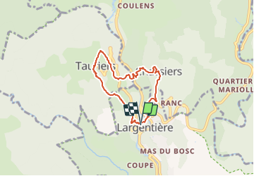
Largentière/Chassiers/Tauriers

Did JP
User

Length
6.7 km

Max alt
437 m

Uphill gradient
333 m
Km-Effort
11.1 km

Min alt
215 m

Downhill gradient
333 m
Boucle
Yes
Creation date :
2021-10-08 17:37:24.5
Updated on :
2021-10-08 17:37:26.659
2h31
Difficulty : Medium

FREE GPS app for hiking
 SityTrail
IGN / Geographical institutes
SityTrail Plus
The world is yours!
About
Trail Walking of 6.7 km to be discovered at Auvergne-Rhône-Alpes, Ardèche, Largentière. This trail is proposed by Did JP.
Description
Depuis Largentière découverte de 2 villages médiévaux et de l'écomusée.
Positioning
Country:
France
Region :
Auvergne-Rhône-Alpes
Department/Province :
Ardèche
Municipality :
Largentière
Location:
Unknown
Start:(Dec)
Start:(UTM)
602654 ; 4932916 (31T) N.
Comments