


vignot 10/10/21
© OpenStreetMap contributors


2h12
Difficulty : Medium


Length
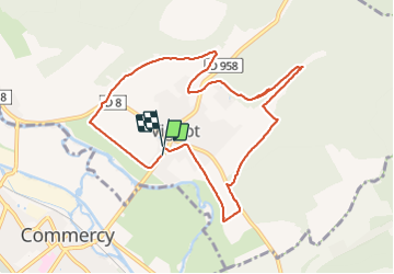
9.3 km
Max alt
288 m
Uphill gradient
132 m
Km-Effort
11 km
Min alt
218 m
Downhill gradient
131 m
Boucle
Yes
Creation date :
2021-10-10 12:31:18.296
Updated on :
2021-10-10 14:43:53.506
2h12
Difficulty : Medium
FREE GPS app for hiking
 SityTrail
IGN / Geographical institutes
SityTrail Plus
The world is yours!
About
Trail Walking of 9.3 km to be discovered at Grand Est, Meuse, Vignot. This trail is proposed by jerome-dupont@laposte.net.
Description
rando bois et plaine
Positioning
Country:
France
Region :
Grand Est
Department/Province :
Meuse
Municipality :
Vignot
Location:
Unknown
Start:(Dec)
Start:(UTM)
691501 ; 5405321 (31U) N.
Comments