


Charmé Som

raygautier
User
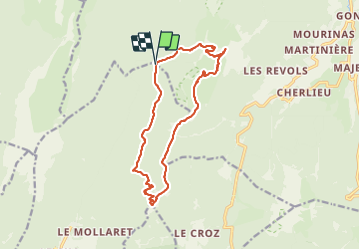

Length
15.5 km

Max alt
1857 m

Uphill gradient
990 m
Km-Effort
29 km

Min alt
1277 m

Downhill gradient
985 m
Boucle
Yes
Creation date :
2021-10-10 06:19:20.0
Updated on :
2021-10-11 07:27:43.952
6h37
Difficulty : Very difficult

FREE GPS app for hiking
 SityTrail
IGN / Geographical institutes
SityTrail Plus
The world is yours!
About
Trail Walking of 15.5 km to be discovered at Auvergne-Rhône-Alpes, Isère, Proveysieux. This trail is proposed by raygautier.
Positioning
Country:
France
Region :
Auvergne-Rhône-Alpes
Department/Province :
Isère
Municipality :
Proveysieux
Location:
Unknown
Start:(Dec)
Start:(UTM)
714746 ; 5022357 (31T) N.
Comments