


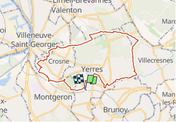
Rando SRIAS Yerres 18 km

jeanmarcMasson
User GUIDE

Length
18.3 km

Max alt
117 m

Uphill gradient
187 m
Km-Effort
21 km

Min alt
30 m

Downhill gradient
186 m
Boucle
Yes
Creation date :
2021-10-11 15:50:59.542
Updated on :
2021-10-11 16:42:00.328
4h39
Difficulty : Very difficult

FREE GPS app for hiking
 SityTrail
IGN / Geographical institutes
SityTrail Plus
The world is yours!
About
Trail Walking of 18.3 km to be discovered at Ile-de-France, Essonne, Yerres. This trail is proposed by jeanmarcMasson.
Description
Départ Gare de Yerres, long de l'Yerres jusqu'au haut de Crosne, puis Bois de la Grange , rond point de l'étoile puis retour par le réveillon et parc Caillebotte.
Positioning
Country:
France
Region :
Ile-de-France
Department/Province :
Essonne
Municipality :
Yerres
Location:
Unknown
Start:(Dec)
Start:(UTM)
461986 ; 5395004 (31U) N.
Comments