


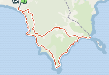
Plage de Gigaro, Cap Lardier, Cap Taillat retour par les vignes 3545 OT

verotrail
User


3h45
Difficulty : Medium

FREE GPS app for hiking
 SityTrail
IGN / Geographical institutes
SityTrail Plus
The world is yours!
About
Trail On foot of 12.6 km to be discovered at Provence-Alpes-Côte d'Azur, Var, La Croix-Valmer. This trail is proposed by verotrail.
Description
Du km 8 (sur la plage) au km 9,5 suivre les pancarte retour plage de Gigaro
il y a des clôtures partout, dues aux incendies mais aussi des propriétaires qui ont fermés certains accès tout en nous indiquant le chemin par des pancartes
sinon retour par le bord de mer ...aller retour
Positioning
Comments