


La voie romaine par Villars et les hauts de Chamalières.

jpcccb
User
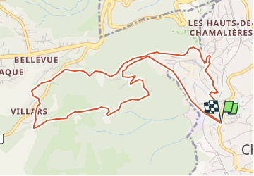

Length
6.5 km

Max alt
724 m

Uphill gradient
263 m
Km-Effort
10 km

Min alt
461 m

Downhill gradient
262 m
Boucle
Yes
Creation date :
2021-10-13 14:15:27.852
Updated on :
2021-10-19 16:49:10.362
2h31
Difficulty : Medium

FREE GPS app for hiking
 SityTrail
IGN / Geographical institutes
SityTrail Plus
The world is yours!
About
Trail Walking of 6.5 km to be discovered at Auvergne-Rhône-Alpes, Puy-de-Dôme, Chamalières. This trail is proposed by jpcccb.
Positioning
Country:
France
Region :
Auvergne-Rhône-Alpes
Department/Province :
Puy-de-Dôme
Municipality :
Chamalières
Location:
Unknown
Start:(Dec)
Start:(UTM)
504188 ; 5069094 (31T) N.
Comments