


Fumay Éric philippe

Tommy Eric
User
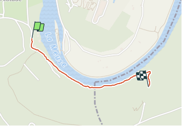

Length
998 m

Max alt
202 m

Uphill gradient
61 m
Km-Effort
1.6 km

Min alt
128 m

Downhill gradient
6 m
Boucle
No
Creation date :
2021-10-14 12:13:47.033
Updated on :
2021-10-14 12:42:03.32
28m
Difficulty : Easy

FREE GPS app for hiking
 SityTrail
IGN / Geographical institutes
SityTrail Plus
The world is yours!
About
Trail Walking of 998 m to be discovered at Grand Est, Ardennes, Fumay. This trail is proposed by Tommy Eric.
Positioning
Country:
France
Region :
Grand Est
Department/Province :
Ardennes
Municipality :
Fumay
Location:
Unknown
Start:(Dec)
Start:(UTM)
621987 ; 5538308 (31U) N.
Comments