


Nolay Le Mont de Sène page 13

grasgilbert
User
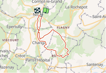

Length
13.8 km

Max alt
514 m

Uphill gradient
259 m
Km-Effort
17.3 km

Min alt
312 m

Downhill gradient
258 m
Boucle
Yes
Creation date :
2021-10-14 14:03:57.655
Updated on :
2025-02-14 17:40:00.93
3h55
Difficulty : Difficult

FREE GPS app for hiking
 SityTrail
IGN / Geographical institutes
SityTrail Plus
The world is yours!
About
Trail Walking of 13.8 km to be discovered at Bourgogne-Franche-Comté, Côte-d'Or, Nolay. This trail is proposed by grasgilbert.
Positioning
Country:
France
Region :
Bourgogne-Franche-Comté
Department/Province :
Côte-d'Or
Municipality :
Nolay
Location:
Unknown
Start:(Dec)
Start:(UTM)
624643 ; 5200861 (31T) N.
Comments
très bien