


roc de toulaud

panetJeanLuc
User
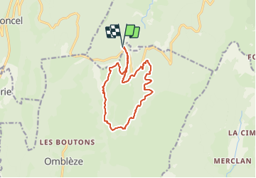

Length
13.6 km

Max alt
1561 m

Uphill gradient
627 m
Km-Effort
22 km

Min alt
1136 m

Downhill gradient
621 m
Boucle
Yes
Creation date :
2021-10-14 07:37:26.209
Updated on :
2021-10-14 15:23:44.861
4h23
Difficulty : Very difficult

FREE GPS app for hiking
 SityTrail
IGN / Geographical institutes
SityTrail Plus
The world is yours!
About
Trail Walking of 13.6 km to be discovered at Auvergne-Rhône-Alpes, Drôme, Bouvante. This trail is proposed by panetJeanLuc.
Positioning
Country:
France
Region :
Auvergne-Rhône-Alpes
Department/Province :
Drôme
Municipality :
Bouvante
Location:
Unknown
Start:(Dec)
Start:(UTM)
677536 ; 4974528 (31T) N.
Comments