


Chantilly Etanf reine Blanche

avdem
User
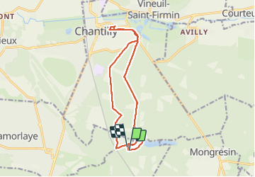

Length
14.9 km

Max alt
88 m

Uphill gradient
143 m
Km-Effort
16.8 km

Min alt
42 m

Downhill gradient
136 m
Boucle
Yes
Creation date :
2021-10-15 07:58:30.952
Updated on :
2021-10-15 15:17:31.852
3h18
Difficulty : Difficult

FREE GPS app for hiking
 SityTrail
IGN / Geographical institutes
SityTrail Plus
The world is yours!
About
Trail Walking of 14.9 km to be discovered at Hauts-de-France, Oise, Coye-la-Forêt. This trail is proposed by avdem.
Description
avec resto
Photos


Positioning
Country:
France
Region :
Hauts-de-France
Department/Province :
Oise
Municipality :
Coye-la-Forêt
Location:
Unknown
Start:(Dec)
Start:(UTM)
462063 ; 5444844 (31U) N.
Comments