


Villemoyenne

MoiClaude
User
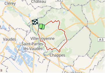

Length
9.4 km

Max alt
171 m

Uphill gradient
96 m
Km-Effort
10.6 km

Min alt
123 m

Downhill gradient
86 m
Boucle
No
Creation date :
2021-10-16 12:03:15.931
Updated on :
2021-10-16 14:12:30.931
2h01
Difficulty : Medium

FREE GPS app for hiking
 SityTrail
IGN / Geographical institutes
SityTrail Plus
The world is yours!
About
Trail Walking of 9.4 km to be discovered at Grand Est, Aube, Villemoyenne. This trail is proposed by MoiClaude.
Description
Super rando
Positioning
Country:
France
Region :
Grand Est
Department/Province :
Aube
Municipality :
Villemoyenne
Location:
Unknown
Start:(Dec)
Start:(UTM)
590893 ; 5337306 (31U) N.
Comments