


St Martin

Djaie60
User
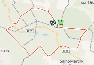

Length
10.9 km

Max alt
219 m

Uphill gradient
302 m
Km-Effort
14.9 km

Min alt
100 m

Downhill gradient
302 m
Boucle
Yes
Creation date :
2021-10-16 17:15:10.476
Updated on :
2021-10-16 17:16:06.569
3h23
Difficulty : Easy

FREE GPS app for hiking
 SityTrail
IGN / Geographical institutes
SityTrail Plus
The world is yours!
About
Trail On foot of 10.9 km to be discovered at Ile-de-France, Val-d'Oise, Saint-Martin-du-Tertre. This trail is proposed by Djaie60.
Positioning
Country:
France
Region :
Ile-de-France
Department/Province :
Val-d'Oise
Municipality :
Saint-Martin-du-Tertre
Location:
Unknown
Start:(Dec)
Start:(UTM)
451352 ; 5441198 (31U) N.
Comments