


Villers-Ste-Gertrude (Durbuy) ADEPS15

thomarche
User
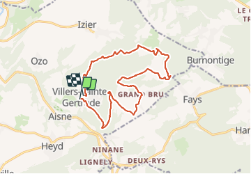

Length
14.9 km

Max alt
370 m

Uphill gradient
459 m
Km-Effort
21 km

Min alt
206 m

Downhill gradient
457 m
Boucle
Yes
Creation date :
2021-10-17 09:52:15.0
Updated on :
2021-10-17 13:53:25.752
3h33
Difficulty : Very difficult

FREE GPS app for hiking
 SityTrail
IGN / Geographical institutes
SityTrail Plus
The world is yours!
About
Trail Walking of 14.9 km to be discovered at Wallonia, Luxembourg, Durbuy. This trail is proposed by thomarche.
Description
Très peu macadam. Superbe. Une partie privée vers la fin dc voir pr d’autres fois...
Positioning
Country:
Belgium
Region :
Wallonia
Department/Province :
Luxembourg
Municipality :
Durbuy
Location:
Unknown
Start:(Dec)
Start:(UTM)
683216 ; 5581975 (31U) N.
Comments