


Le But de Nève

crocau
User
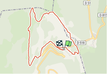

Length
5.7 km

Max alt
1634 m

Uphill gradient
404 m
Km-Effort
11.1 km

Min alt
1238 m

Downhill gradient
406 m
Boucle
Yes
Creation date :
2021-10-17 10:51:21.304
Updated on :
2021-10-17 13:58:32.28
2h40
Difficulty : Medium

FREE GPS app for hiking
 SityTrail
IGN / Geographical institutes
SityTrail Plus
The world is yours!
About
Trail Walking of 5.7 km to be discovered at Auvergne-Rhône-Alpes, Drôme, Chamaloc. This trail is proposed by crocau.
Photos


Positioning
Country:
France
Region :
Auvergne-Rhône-Alpes
Department/Province :
Drôme
Municipality :
Chamaloc
Location:
Unknown
Start:(Dec)
Start:(UTM)
689497 ; 4967751 (31T) N.
Comments
Par temps très clair, on apercevra le ..Pic St Loup à côté de Montpellier !!