


2021-10-17_22h12m42_ailhon.gpx (1)

Linerou
User
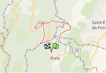

Length
6.9 km

Max alt
464 m

Uphill gradient
233 m
Km-Effort
10 km

Min alt
266 m

Downhill gradient
232 m
Boucle
Yes
Creation date :
2021-10-17 20:12:42.719
Updated on :
2023-12-31 10:54:43.024
2h16
Difficulty : Medium

FREE GPS app for hiking
 SityTrail
IGN / Geographical institutes
SityTrail Plus
The world is yours!
About
Trail Walking of 6.9 km to be discovered at Auvergne-Rhône-Alpes, Ardèche, Fons. This trail is proposed by Linerou.
Description
Ballade de quelques heures autour d\'Ailhon (église, arboretum), dans les pins sur des sentiers faciles et agréables. Bien pour l\'après-midi, par exemple.
Positioning
Country:
France
Region :
Auvergne-Rhône-Alpes
Department/Province :
Ardèche
Municipality :
Fons
Location:
Unknown
Start:(Dec)
Start:(UTM)
606897 ; 4937767 (31T) N.
Comments