


reco TPB02

sterdyniak
User
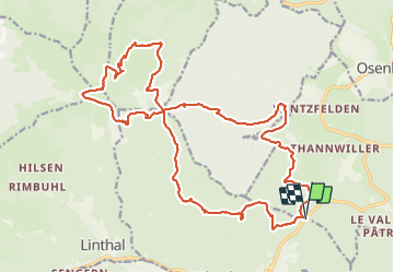

Length
24 km

Max alt
1266 m

Uphill gradient
1123 m
Km-Effort
39 km

Min alt
412 m

Downhill gradient
1123 m
Boucle
Yes
Creation date :
2021-09-12 07:31:54.144
Updated on :
2021-10-18 05:51:38.23
4h50
Difficulty : Medium

FREE GPS app for hiking
 SityTrail
IGN / Geographical institutes
SityTrail Plus
The world is yours!
About
Trail Trail of 24 km to be discovered at Grand Est, Haut-Rhin, Soultzmatt. This trail is proposed by sterdyniak.
Description
rando trail
Positioning
Country:
France
Region :
Grand Est
Department/Province :
Haut-Rhin
Municipality :
Soultzmatt
Location:
Unknown
Start:(Dec)
Start:(UTM)
365046 ; 5312758 (32T) N.
Comments