


St. Aubin le Guichard

werth
User
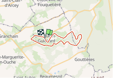

Length
12.1 km

Max alt
165 m

Uphill gradient
120 m
Km-Effort
13.7 km

Min alt
114 m

Downhill gradient
121 m
Boucle
Yes
Creation date :
2021-10-19 07:01:44.173
Updated on :
2021-10-19 11:11:27.408
3h35
Difficulty : Medium

FREE GPS app for hiking
 SityTrail
IGN / Geographical institutes
SityTrail Plus
The world is yours!
About
Trail Walking of 12.1 km to be discovered at Normandy, Eure, Mesnil-en-Ouche. This trail is proposed by werth.
Positioning
Country:
France
Region :
Normandy
Department/Province :
Eure
Municipality :
Mesnil-en-Ouche
Location:
Unknown
Start:(Dec)
Start:(UTM)
331937 ; 5434293 (31U) N.
Comments