


cret du Taillefer

papou73
User
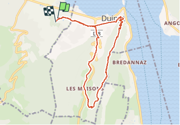

Length
10.8 km

Max alt
764 m

Uphill gradient
364 m
Km-Effort
15.6 km

Min alt
451 m

Downhill gradient
362 m
Boucle
Yes
Creation date :
2021-10-20 06:54:17.096
Updated on :
2021-10-20 13:34:21.06
3h30
Difficulty : Difficult

FREE GPS app for hiking
 SityTrail
IGN / Geographical institutes
SityTrail Plus
The world is yours!
About
Trail Walking of 10.8 km to be discovered at Auvergne-Rhône-Alpes, Upper Savoy, Saint-Jorioz. This trail is proposed by papou73.
Positioning
Country:
France
Region :
Auvergne-Rhône-Alpes
Department/Province :
Upper Savoy
Municipality :
Saint-Jorioz
Location:
Unknown
Start:(Dec)
Start:(UTM)
281229 ; 5078760 (32T) N.
Comments