


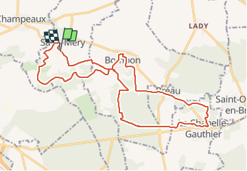
Saint Mery 21,2 km

jeanmarcMasson
User GUIDE

Length
21 km

Max alt
116 m

Uphill gradient
186 m
Km-Effort
24 km

Min alt
74 m

Downhill gradient
185 m
Boucle
Yes
Creation date :
2021-10-20 07:56:46.6
Updated on :
2021-10-20 14:15:03.95
5h01
Difficulty : Very difficult

FREE GPS app for hiking
 SityTrail
IGN / Geographical institutes
SityTrail Plus
The world is yours!
About
Trail Walking of 21 km to be discovered at Ile-de-France, Seine-et-Marne, Saint-Méry. This trail is proposed by jeanmarcMasson.
Positioning
Country:
France
Region :
Ile-de-France
Department/Province :
Seine-et-Marne
Municipality :
Saint-Méry
Location:
Unknown
Start:(Dec)
Start:(UTM)
487242 ; 5380280 (31U) N.
Comments