


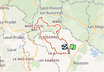
Croix de Mercoirol

GOIOLIRIBES
User

Length
15 km

Max alt
500 m

Uphill gradient
454 m
Km-Effort
21 km

Min alt
270 m

Downhill gradient
454 m
Boucle
Yes
Creation date :
2021-10-21 07:20:01.746
Updated on :
2021-10-21 13:23:01.198
6h02
Difficulty : Difficult

FREE GPS app for hiking
 SityTrail
IGN / Geographical institutes
SityTrail Plus
The world is yours!
About
Trail Walking of 15 km to be discovered at Occitania, Gard, Rousson. This trail is proposed by GOIOLIRIBES.
Positioning
Country:
France
Region :
Occitania
Department/Province :
Gard
Municipality :
Rousson
Location:
Unknown
Start:(Dec)
Start:(UTM)
590480 ; 4895277 (31T) N.
Comments