


Xavier fumay

Tommy Eric
User

Length
24 km

Max alt
396 m

Uphill gradient
543 m
Km-Effort
31 km

Min alt
117 m

Downhill gradient
391 m
Boucle
No
Creation date :
2021-10-23 15:45:18.215
Updated on :
2021-10-23 17:20:14.553
1h34
Difficulty : Very difficult

FREE GPS app for hiking
 SityTrail
IGN / Geographical institutes
SityTrail Plus
The world is yours!
About
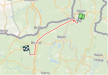
Trail Walking of 24 km to be discovered at Grand Est, Ardennes, Haybes. This trail is proposed by Tommy Eric.
Positioning
Country:
France
Region :
Grand Est
Department/Province :
Ardennes
Municipality :
Haybes
Location:
Unknown
Start:(Dec)
Start:(UTM)
622642 ; 5537980 (31U) N.
Comments