


labastide st george

Emmanuelle Benoit
User
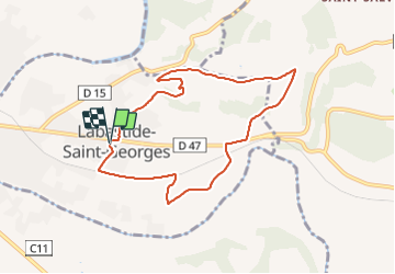

Length
8.2 km

Max alt
206 m

Uphill gradient
135 m
Km-Effort
10 km

Min alt
131 m

Downhill gradient
133 m
Boucle
Yes
Creation date :
2021-10-24 07:25:04.073
Updated on :
2021-10-24 09:21:44.024
1h33
Difficulty : Medium

FREE GPS app for hiking
 SityTrail
IGN / Geographical institutes
SityTrail Plus
The world is yours!
About
Trail Walking of 8.2 km to be discovered at Occitania, Tarn, Labastide-Saint-Georges. This trail is proposed by Emmanuelle Benoit.
Positioning
Country:
France
Region :
Occitania
Department/Province :
Tarn
Municipality :
Labastide-Saint-Georges
Location:
Unknown
Start:(Dec)
Start:(UTM)
406734 ; 4839118 (31T) N.
Comments