


MAYRES

raygautier
User
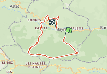

Length
17 km

Max alt
1526 m

Uphill gradient
1304 m
Km-Effort
35 km

Min alt
586 m

Downhill gradient
1384 m
Boucle
No
Creation date :
2021-10-24 07:11:51.0
Updated on :
2021-10-24 15:46:57.163
5h30
Difficulty : Very difficult

FREE GPS app for hiking
 SityTrail
IGN / Geographical institutes
SityTrail Plus
The world is yours!
About
Trail Walking of 17 km to be discovered at Auvergne-Rhône-Alpes, Ardèche, Mayres. This trail is proposed by raygautier.
Positioning
Country:
France
Region :
Auvergne-Rhône-Alpes
Department/Province :
Ardèche
Municipality :
Mayres
Location:
Unknown
Start:(Dec)
Start:(UTM)
588581 ; 4945741 (31T) N.
Comments