


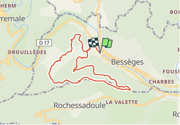
Bessèges - Le RONC ROUGE

GOIOLIRIBES
User


4h42
Difficulty : Difficult

FREE GPS app for hiking
 SityTrail
IGN / Geographical institutes
SityTrail Plus
The world is yours!
About
Trail Walking of 9.8 km to be discovered at Occitania, Gard, Bessèges. This trail is proposed by GOIOLIRIBES.
Description
Stationner sur le Parking face hôtel de ville. Bonne montée dès le départ - randonnée courte mais agréable, sous les châtaigniers en partie, et vue à 360° depuis la chapelle.
temps de marche compris avec pause casse croûte.
Positioning
Comments