


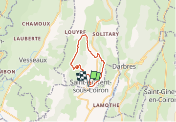
Saint-Laurent de Coiron

raab
User

Length
10.6 km

Max alt
682 m

Uphill gradient
273 m
Km-Effort
14.2 km

Min alt
449 m

Downhill gradient
274 m
Boucle
Yes
Creation date :
2021-10-28 07:37:21.622
Updated on :
2021-10-28 13:05:04.087
5h26
Difficulty : Difficult

FREE GPS app for hiking
 SityTrail
IGN / Geographical institutes
SityTrail Plus
The world is yours!
About
Trail Walking of 10.6 km to be discovered at Auvergne-Rhône-Alpes, Ardèche, Saint-Laurent-sous-Coiron. This trail is proposed by raab.
Positioning
Country:
France
Region :
Auvergne-Rhône-Alpes
Department/Province :
Ardèche
Municipality :
Saint-Laurent-sous-Coiron
Location:
Unknown
Start:(Dec)
Start:(UTM)
617428 ; 4943710 (31T) N.
Comments