


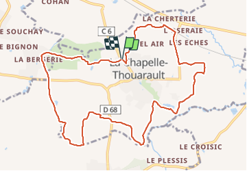
TA La Chapelle Thouarault

nolsim
User

Length
11.5 km

Max alt
63 m

Uphill gradient
84 m
Km-Effort
12.6 km

Min alt
29 m

Downhill gradient
83 m
Boucle
Yes
Creation date :
2021-10-28 12:27:43.878
Updated on :
2021-10-28 15:10:21.976
2h30
Difficulty : Very easy

FREE GPS app for hiking
 SityTrail
IGN / Geographical institutes
SityTrail Plus
The world is yours!
About
Trail Walking of 11.5 km to be discovered at Brittany, Ille-et-Vilaine, La Chapelle-Thouarault. This trail is proposed by nolsim.
Positioning
Country:
France
Region :
Brittany
Department/Province :
Ille-et-Vilaine
Municipality :
La Chapelle-Thouarault
Location:
Unknown
Start:(Dec)
Start:(UTM)
584190 ; 5330969 (30U) N.
Comments