


badonviller_20kms

any1950
User
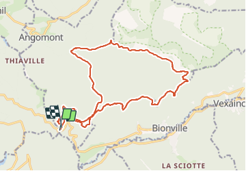

Length
20 km

Max alt
668 m

Uphill gradient
619 m
Km-Effort
29 km

Min alt
371 m

Downhill gradient
611 m
Boucle
Yes
Creation date :
2021-10-28 06:56:17.855
Updated on :
2021-10-28 18:56:33.532
8h00
Difficulty : Very difficult

FREE GPS app for hiking
 SityTrail
IGN / Geographical institutes
SityTrail Plus
The world is yours!
About
Trail Walking of 20 km to be discovered at Grand Est, Meurthe-et-Moselle, Angomont. This trail is proposed by any1950.
Positioning
Country:
France
Region :
Grand Est
Department/Province :
Meurthe-et-Moselle
Municipality :
Angomont
Location:
Unknown
Start:(Dec)
Start:(UTM)
348978 ; 5372106 (32U) N.
Comments