Thorigné Fouillard reco

nolsim
User
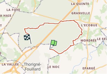

Length
12.8 km

Max alt
120 m

Uphill gradient
125 m
Km-Effort
14.5 km

Min alt
57 m

Downhill gradient
151 m
Boucle
No
Creation date :
2021-10-29 07:00:02.157
Updated on :
2021-10-29 09:49:38.636
2h37
Difficulty : Easy

FREE GPS app for hiking
 SityTrail
IGN / Geographical institutes
SityTrail Plus
The world is yours!
About
Trail Walking of 12.8 km to be discovered at Brittany, Ille-et-Vilaine, Thorigné-Fouillard. This trail is proposed by nolsim.
Positioning
Country:
France
Region :
Brittany
Department/Province :
Ille-et-Vilaine
Municipality :
Thorigné-Fouillard
Location:
Unknown
Start:(Dec)
Start:(UTM)
607064 ; 5335862 (30U) N.
Comments