


Col_Canadel_Montjean

essius
User
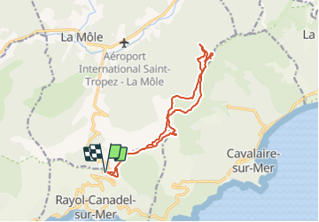

Length
14.6 km

Max alt
524 m

Uphill gradient
537 m
Km-Effort
22 km

Min alt
263 m

Downhill gradient
537 m
Boucle
Yes
Creation date :
2021-10-30 08:40:06.679
Updated on :
2021-10-30 08:40:06.679

FREE GPS app for hiking
 SityTrail
IGN / Geographical institutes
SityTrail Plus
The world is yours!
About
Trail of 14.6 km to be discovered at Provence-Alpes-Côte d'Azur, Var, Rayol-Canadel-sur-Mer. This trail is proposed by essius.
Positioning
Country:
France
Region :
Provence-Alpes-Côte d'Azur
Department/Province :
Var
Municipality :
Rayol-Canadel-sur-Mer
Location:
Unknown
Start:(Dec)
Start:(UTM)
294725 ; 4782678 (32T) N.
Comments