


2021-10-30_12h10m37_gpx-trace

raab
User
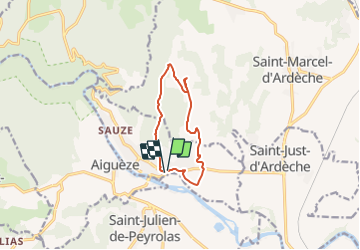

Length
9.6 km

Max alt
220 m

Uphill gradient
196 m
Km-Effort
12.2 km

Min alt
48 m

Downhill gradient
192 m
Boucle
Yes
Creation date :
2021-10-30 10:10:38.166
Updated on :
2021-11-10 13:47:55.519
2h46
Difficulty : Difficult

FREE GPS app for hiking
 SityTrail
IGN / Geographical institutes
SityTrail Plus
The world is yours!
About
Trail Walking of 9.6 km to be discovered at Auvergne-Rhône-Alpes, Ardèche, Saint-Martin-d'Ardèche. This trail is proposed by raab.
Positioning
Country:
France
Region :
Auvergne-Rhône-Alpes
Department/Province :
Ardèche
Municipality :
Saint-Martin-d'Ardèche
Location:
Unknown
Start:(Dec)
Start:(UTM)
625525 ; 4906617 (31T) N.
Comments