


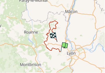
Stpierre cublize beaujeu ternant

d.rognon
User

Length
165 km

Max alt
900 m

Uphill gradient
4570 m
Km-Effort
227 km

Min alt
240 m

Downhill gradient
4933 m
Boucle
No
Creation date :
2021-10-30 05:36:07.113
Updated on :
2021-10-31 08:07:42.64
10h55
Difficulty : Very easy

FREE GPS app for hiking
 SityTrail
IGN / Geographical institutes
SityTrail Plus
The world is yours!
About
Trail Quad of 165 km to be discovered at Auvergne-Rhône-Alpes, Rhône, Saint-Pierre-la-Palud. This trail is proposed by d.rognon.
Positioning
Country:
France
Region :
Auvergne-Rhône-Alpes
Department/Province :
Rhône
Municipality :
Saint-Pierre-la-Palud
Location:
Unknown
Start:(Dec)
Start:(UTM)
627380 ; 5070454 (31T) N.
Comments