


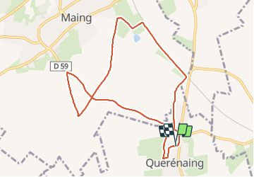
Querenaing, rando Pascal 9 Km

papiou
User


2h00
Difficulty : Medium

FREE GPS app for hiking
 SityTrail
IGN / Geographical institutes
SityTrail Plus
The world is yours!
About
Trail Walking of 9 km to be discovered at Hauts-de-France, Nord, Quérénaing. This trail is proposed by papiou.
Description
Rdv. salle des fêtes et face à celle ci partir à gauche pour rejoindre chemin longeant pâture et vers la gauche rejoindre rue de St Quentin par un droite-gauche, continuer jusqu'à voie ferrée et à gauche aller jusqu'au calvaire, par la gauche rejoindre carrefour de l'abri de chasse, tourner à droite pour rejoindre rue pavé de Maing et à droite revenir au départ par longue route de pavé
Positioning
Comments