


Randonnée à Pepinster

Ko-Rando
User
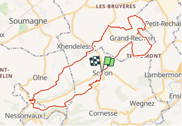

Length
22 km

Max alt
313 m

Uphill gradient
417 m
Km-Effort
27 km

Min alt
123 m

Downhill gradient
414 m
Boucle
Yes
Creation date :
2021-10-31 08:13:48.074
Updated on :
2021-10-31 13:16:03.544
4h40
Difficulty : Easy

FREE GPS app for hiking
 SityTrail
IGN / Geographical institutes
SityTrail Plus
The world is yours!
About
Trail Walking of 22 km to be discovered at Wallonia, Liège, Pepinster. This trail is proposed by Ko-Rando.
Description
Bienvenu au Pays de Herve !
Durant cette rando, vous découvrirez un superbe paysage et quelques beaux points de vue 🥾
Photos


21 photos in total. Please click on a photo to see them all in the gallery.
Positioning
Country:
Belgium
Region :
Wallonia
Department/Province :
Liège
Municipality :
Pepinster
Location:
Unknown
Start:(Dec)
Start:(UTM)
697485 ; 5608202 (31U) N.
Comments