Arfons panorama orientation Montalric

tabouelle
User
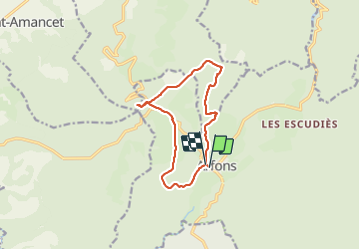

Length
11.6 km

Max alt
819 m

Uphill gradient
232 m
Km-Effort
14.8 km

Min alt
637 m

Downhill gradient
239 m
Boucle
Yes
Creation date :
2021-10-31 09:25:08.279
Updated on :
2021-10-31 13:31:24.904
3h11
Difficulty : Easy

FREE GPS app for hiking
 SityTrail
IGN / Geographical institutes
SityTrail Plus
The world is yours!
About
Trail Walking of 11.6 km to be discovered at Occitania, Tarn, Arfons. This trail is proposed by tabouelle.
Positioning
Country:
France
Region :
Occitania
Department/Province :
Tarn
Municipality :
Arfons
Location:
Unknown
Start:(Dec)
Start:(UTM)
432520 ; 4808890 (31T) N.
Comments