


tour des antznnes

bena42
User
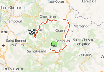

Length
20 km

Max alt
889 m

Uphill gradient
437 m
Km-Effort
27 km

Min alt
556 m

Downhill gradient
680 m
Boucle
No
Creation date :
2021-10-31 14:00:40.967
Updated on :
2021-10-31 16:26:05.587
2h24
Difficulty : Medium

FREE GPS app for hiking
 SityTrail
IGN / Geographical institutes
SityTrail Plus
The world is yours!
About
Trail Mountain bike of 20 km to be discovered at Auvergne-Rhône-Alpes, Loire, Saint-Héand. This trail is proposed by bena42.
Positioning
Country:
France
Region :
Auvergne-Rhône-Alpes
Department/Province :
Loire
Municipality :
Saint-Héand
Location:
Unknown
Start:(Dec)
Start:(UTM)
609939 ; 5042944 (31T) N.
Comments