


Le Tracol.. toulaud

raygautier
User
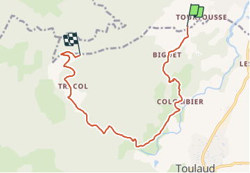

Length
7.6 km

Max alt
453 m

Uphill gradient
367 m
Km-Effort
11.7 km

Min alt
157 m

Downhill gradient
126 m
Boucle
No
Creation date :
2021-10-31 11:14:48.0
Updated on :
2021-10-31 17:09:00.899
3h33
Difficulty : Medium

FREE GPS app for hiking
 SityTrail
IGN / Geographical institutes
SityTrail Plus
The world is yours!
About
Trail Walking of 7.6 km to be discovered at Auvergne-Rhône-Alpes, Ardèche, Saint-Péray. This trail is proposed by raygautier.
Positioning
Country:
France
Region :
Auvergne-Rhône-Alpes
Department/Province :
Ardèche
Municipality :
Saint-Péray
Location:
Unknown
Start:(Dec)
Start:(UTM)
643235 ; 4975976 (31T) N.
Comments