


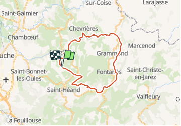
Tour des antennes par Fontanes et Aveizieux

bena42
User

Length
27 km

Max alt
889 m

Uphill gradient
718 m
Km-Effort
37 km

Min alt
556 m

Downhill gradient
716 m
Boucle
Yes
Creation date :
2021-10-31 18:09:43.579
Updated on :
2021-10-31 18:10:14.045
2h32
Difficulty : Difficult

FREE GPS app for hiking
 SityTrail
IGN / Geographical institutes
SityTrail Plus
The world is yours!
About
Trail Mountain bike of 27 km to be discovered at Auvergne-Rhône-Alpes, Loire, Saint-Héand. This trail is proposed by bena42.
Positioning
Country:
France
Region :
Auvergne-Rhône-Alpes
Department/Province :
Loire
Municipality :
Saint-Héand
Location:
Unknown
Start:(Dec)
Start:(UTM)
607224 ; 5045145 (31T) N.
Comments