


Stavelot 7

xtislair
User
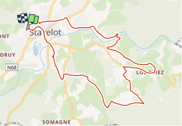

Length
11.4 km

Max alt
509 m

Uphill gradient
312 m
Km-Effort
15.6 km

Min alt
276 m

Downhill gradient
321 m
Boucle
Yes
Creation date :
2021-11-01 07:31:06.165
Updated on :
2021-11-01 07:39:32.813
3h31
Difficulty : Difficult

FREE GPS app for hiking
 SityTrail
IGN / Geographical institutes
SityTrail Plus
The world is yours!
About
Trail Walking of 11.4 km to be discovered at Wallonia, Liège, Stavelot. This trail is proposed by xtislair.
Positioning
Country:
Belgium
Region :
Wallonia
Department/Province :
Liège
Municipality :
Stavelot
Location:
Unknown
Start:(Dec)
Start:(UTM)
707857 ; 5586575 (31U) N.
Comments