


Epinal dogneville

Titinechris
User
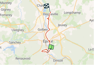

Length
15.5 km

Max alt
455 m

Uphill gradient
298 m
Km-Effort
19.6 km

Min alt
306 m

Downhill gradient
316 m
Boucle
No
Creation date :
2021-11-01 08:54:11.585
Updated on :
2021-11-01 11:31:46.517
2h37
Difficulty : Very difficult

FREE GPS app for hiking
 SityTrail
IGN / Geographical institutes
SityTrail Plus
The world is yours!
About
Trail Walking of 15.5 km to be discovered at Grand Est, Vosges, Épinal. This trail is proposed by Titinechris.
Positioning
Country:
France
Region :
Grand Est
Department/Province :
Vosges
Municipality :
Épinal
Location:
Unknown
Start:(Dec)
Start:(UTM)
310334 ; 5336613 (32U) N.
Comments