


Forêt Bernay

lucmarescot
User
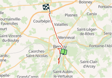

Length
11.8 km

Max alt
167 m

Uphill gradient
152 m
Km-Effort
13.7 km

Min alt
103 m

Downhill gradient
117 m
Boucle
No
Creation date :
2021-11-01 10:10:08.0
Updated on :
2021-11-01 12:42:05.747
2h31
Difficulty : Unknown

FREE GPS app for hiking
 SityTrail
IGN / Geographical institutes
SityTrail Plus
The world is yours!
About
Trail Orienteering of 11.8 km to be discovered at Normandy, Eure, Bernay. This trail is proposed by lucmarescot.
Description
Point
Positioning
Country:
France
Region :
Normandy
Department/Province :
Eure
Municipality :
Bernay
Location:
Unknown
Start:(Dec)
Start:(UTM)
324544 ; 5438305 (31U) N.
Comments