


Bissy-G2

Valmeinier
User
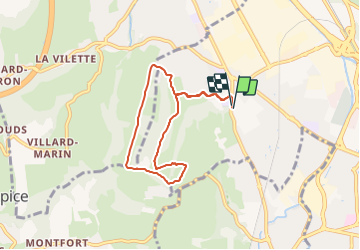

Length
6.6 km

Max alt
434 m

Uphill gradient
239 m
Km-Effort
9.8 km

Min alt
265 m

Downhill gradient
239 m
Boucle
Yes
Creation date :
2021-11-02 15:08:06.961
Updated on :
2021-11-02 15:08:06.961
--
Difficulty : Unknown

FREE GPS app for hiking
 SityTrail
IGN / Geographical institutes
SityTrail Plus
The world is yours!
About
Trail Walking of 6.6 km to be discovered at Auvergne-Rhône-Alpes, Savoy, Chambéry. This trail is proposed by Valmeinier.
Positioning
Country:
France
Region :
Auvergne-Rhône-Alpes
Department/Province :
Savoy
Municipality :
Chambéry
Location:
Unknown
Start:(Dec)
Start:(UTM)
725289 ; 5051243 (31T) N.
Comments