


azelot

ZAMBAUX
User
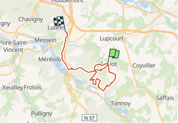

Length
21 km

Max alt
335 m

Uphill gradient
342 m
Km-Effort
26 km

Min alt
225 m

Downhill gradient
354 m
Boucle
No
Creation date :
2021-11-04 12:47:48.83
Updated on :
2021-11-04 16:16:21.754
2h59
Difficulty : Difficult

FREE GPS app for hiking
 SityTrail
IGN / Geographical institutes
SityTrail Plus
The world is yours!
About
Trail Walking of 21 km to be discovered at Grand Est, Meurthe-et-Moselle, Azelot. This trail is proposed by ZAMBAUX.
Positioning
Country:
France
Region :
Grand Est
Department/Province :
Meurthe-et-Moselle
Municipality :
Azelot
Location:
Unknown
Start:(Dec)
Start:(UTM)
295876 ; 5385240 (32U) N.
Comments