


Col de caux .. laval d'aix

raygautier
User
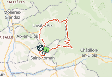

Length
16.1 km

Max alt
1160 m

Uphill gradient
747 m
Km-Effort
26 km

Min alt
531 m

Downhill gradient
732 m
Boucle
No
Creation date :
2021-11-04 08:29:44.0
Updated on :
2021-11-06 10:32:24.237
6h33
Difficulty : Very difficult

FREE GPS app for hiking
 SityTrail
IGN / Geographical institutes
SityTrail Plus
The world is yours!
About
Trail Walking of 16.1 km to be discovered at Auvergne-Rhône-Alpes, Drôme, Saint-Roman. This trail is proposed by raygautier.
Positioning
Country:
France
Region :
Auvergne-Rhône-Alpes
Department/Province :
Drôme
Municipality :
Saint-Roman
Location:
Unknown
Start:(Dec)
Start:(UTM)
692757 ; 4951631 (31T) N.
Comments