


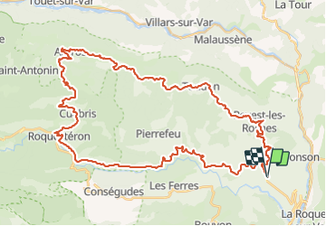
boucle Gilette Ascros Cuebris (par piste) Gilette

franquen
User

Length
56 km

Max alt
1155 m

Uphill gradient
1334 m
Km-Effort
74 km

Min alt
278 m

Downhill gradient
1333 m
Boucle
Yes
Creation date :
2021-11-05 09:54:02.578
Updated on :
2021-11-07 16:38:48.079
4h07
Difficulty : Easy

FREE GPS app for hiking
 SityTrail
IGN / Geographical institutes
SityTrail Plus
The world is yours!
About
Trail Mountain bike of 56 km to be discovered at Provence-Alpes-Côte d'Azur, Maritime Alps, Gilette. This trail is proposed by franquen.
Description
rando agreable : pente régulière, beaux paysages, un peu de piste en descente pour le fun.
Positioning
Country:
France
Region :
Provence-Alpes-Côte d'Azur
Department/Province :
Maritime Alps
Municipality :
Gilette
Location:
Unknown
Start:(Dec)
Start:(UTM)
352473 ; 4857056 (32T) N.
Comments