


Puech Margot

cedric.fargues
User

Length
6.6 km

Max alt
886 m

Uphill gradient
144 m
Km-Effort
8.5 km

Min alt
795 m

Downhill gradient
149 m
Boucle
Yes
Creation date :
2021-11-05 14:31:07.0
Updated on :
2021-11-05 16:28:39.715
1h57
Difficulty : Easy

FREE GPS app for hiking
 SityTrail
IGN / Geographical institutes
SityTrail Plus
The world is yours!
About
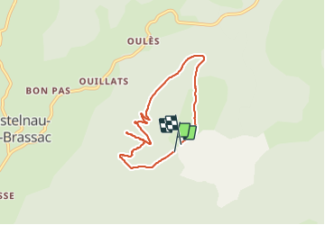
Trail Walking of 6.6 km to be discovered at Occitania, Tarn, Fontrieu. This trail is proposed by cedric.fargues.
Positioning
Country:
France
Region :
Occitania
Department/Province :
Tarn
Municipality :
Fontrieu
Location:
Castelnau-de-Brassac
Start:(Dec)
Start:(UTM)
463198 ; 4832576 (31T) N.
Comments