


exp_5 nov. 2021 à 12-08-36.gpx

liebniz
User
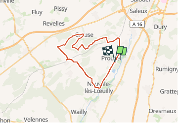

Length
24 km

Max alt
134 m

Uphill gradient
328 m
Km-Effort
28 km

Min alt
40 m

Downhill gradient
328 m
Boucle
Yes
Creation date :
2021-11-05 19:02:56.472
Updated on :
2023-05-05 06:50:51.715
6h40
Difficulty : Medium

FREE GPS app for hiking
 SityTrail
IGN / Geographical institutes
SityTrail Plus
The world is yours!
About
Trail Equestrian of 24 km to be discovered at Hauts-de-France, Somme, Prouzel. This trail is proposed by liebniz.
Positioning
Country:
France
Region :
Hauts-de-France
Department/Province :
Somme
Municipality :
Prouzel
Location:
Unknown
Start:(Dec)
Start:(UTM)
442903 ; 5518357 (31U) N.
Comments